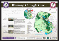
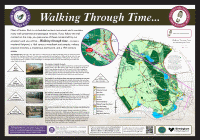
Archaeology Walks – Walking Through Time
Six routes into the past of Sutton Park
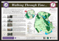
Walk No 1: Starting from Streetly Gate
Suggested route about 2.5 miles (approx. 1.5 hours)
From Streetly Gate follow the path to the right of the panel. Turn along a path to the right into the woodland. After a short distance this path crosses the Roman road.
Marker No 1.1 is near the path
The Roman road consists of a raised carriageway or agger of compacted gravel, slight ditches along each side of it dug to mark the route for the road builders and many pits on each side of the road where gravel was quarried to make the agger.
Return back to the main path and continue along it and over the railway line. Take great care over the level crossing. The path now leads you along the Roman road.
Marker No 1.2 is alongside the Roman road
Walk along the Roman road to the edge of the Park, and along the path, keeping the fence of the pony enclosure to your right. Just after the path goes through a gate you can see a bank and ditch which subdivided the medieval deer park. Continue along the path.
Marker No 1.3 is on the left, in front of the Park perimeter fence
The ditch and bank boundary of the deer park, created in the 12th century by King Henry I. Originally the bank rose over 2 metres above the bottom of the ditch and was topped by a paling fence to stop the deer escaping. You can see the ditch and bank along the whole of the Park boundary from Four Oaks Gate to Banners Gate.
By the Milking Gate pedestrian entrance to the Park turn right downhill and then fork left. Continue along the path.
Marker 1.4 is on your right and points to one of the burnt mounds, which has an oak tree growing on top of it.
The burnt mound was formed about 3000 years ago from discarded heat-shattered stones. They were heated by fire, then water was poured on them to produce steam for a “sauna”. You will see stones with jagged edges and hairline cracks on the mound. Pick them up and look at them, but do not remove them from the site. Look around you to spot more burnt mounds.
Continue along the path, turn right at a junction and follow the path downhill to Little Bracebridge Pool.
Marker 1.5 is near the bench next to the pool.
Little Bracebridge Pool was originally part of Bracebridge Pool. Hollows in “The Bowers” may be peat pits that were later enlarged to entice ducks for shooting. The brick arched bridge over the stream was built in the 19th century.
Walk over the bridge and turn left along the track.
Marker No 1.6 is beside the path
The bank and ditch (woodbank) was constructed around Darnel Hurst in the 16th century to keep grazing animals out of coppiced wood.
Continue along the path, cross the bridge over the railway and continue through Darnel Hurst up to the tarmac road. Turn right along the road to get back to Streetly Gate. Watch out for traffic.
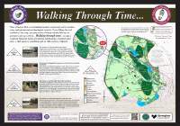
Walk No 2: Starting from Town Gate
Suggested route about 2.5 miles (approx. 1.5 hours)
From Town Gate walk alongside the tarmac road towards the Visitor Centre. The hollow on the right opposite the Visitor Centre was a bunker in a 19th century golf course. Turn right along the road to Keepers Pool, then go along the dam when you reach the pool.
Marker 2.1 is on the dam of Keepers Pool near a bench
Keepers Pool was created in the Middle Ages as a fish pond. Material to build the dam was obtained from a quarry which you can see at the far end. The dam was reinforced with stone in the 15th century.
Return to the tarmac road and continue along it.
Marker no 2.2 is alongside the road
A low bank at right angles to the road, with a slight ditch alongside it, was a subdivision of the medieval deer park to create an enclosure into which deer were rounded up for hunting. The bank would have had a hedge or fence on top of it. You can see more banks and ditches nearby, on both sides of the road.
Continue along the road then turn right along a path up the hill to reach woodland.
Marker no 2.3 is on the edge of the woods
The bank and ditch (woodbank) was constructed around Lower Nut Hurst in the 16th century to keep grazing animals out of coppiced wood. Inside the wood, a short distance to your right, you can see an older bank and ditch that subdivided the medieval deer park.
Walk along the path up the slope through the wood. At the highest point there are some shallow pits where felled trees were sawn up. Turn right down the hill to reach Blackroot Pool at the bottom of the slope, and walk along the dam.
Marker no 2.4 is at the far end of the dam, near the tarmac road
Blackroot Pool was created in 1759 to provide water power to drive a mill for processing leather. The mill stood below the dam near the marker. On the other side of the road is the quarry where material to build the dam was obtained.
Return to the Town Gate along the tarmac road.
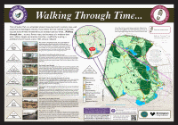
Walk No 3: Starting from Banners Gate
Suggested route about 2.5 miles (approx. 1.5 hours)
From the car park, walk along the surfaced track alongside the wood. This is Westwood Coppice, which was planted in the 18th century and surrounded by a bank and ditch which you can see next to the track. Continue straight on beyond the corner of the wood up to the cinder track (Lord Donegal’s Ride) and turn left along it.
Marker no 3.1 is alongside the track, next to the slight but prominent grass-covered bank that is the Roman road
The Roman road consists of a raised carriageway or agger of compacted gravel, slight ditches along each side of it dug to mark the route for the road builders and many pits on each side of the road where gravel was quarried to make the agger.
Continue along the cinder track almost to the entrance to the Park, turn right into the woods near the fenced sub-station and walk towards the Park boundary fence.
Marker no 3.2 is just off the path, inside the wood
The ditch and bank boundary of the deer park, created in the 12th century by King Henry I. Originally the bank rose over 2 metres above the bottom of the ditch and was topped by a paling fence to stop the deer escaping. You can see the ditch and bank along the whole of the Park boundary from Four Oaks Gate to Banners Gate.
Return to the cinder track and walk back along it, continuing until you see a tree-covered mound on your left.
Marker no 3.3 is near the path
The concrete-lined trench sheltered the soldiers who manned the targets of a 19th century military rifle range in the Longmoor Valley, and the mound behind it stopped stray bullets. The track alongside was created by the Earl of Donegal (who lived at Fisherwick near Lichfield) in the 18th century as a route for fox hunters riding into the Park.
Continue along the cinder track over the bridge across the stream and turn right before the slope, to follow a path.
Marker no 3.4 is just off the path
The trench beyond the marker was a military practice trench dug in a zig zag shape so that there was no direct line of fire along the trench. Longmoor Valley was used for military training during the 19th century and again during the First World War.
Return to the path and continue along it for a short distance.
Marker no 3.5 is just off the path at a point where you can see the well over the slope
Rowton’s Well is a natural spring surrounded by a stone wall. Its water was believed to have curative powers and was used in Birmingham Eye Hospital. Peat was dug for fuel in the 18th century from The Old Peat Pit on the other side of the stream.
Return to the path and continue along it.
Marker no 3.6 is on the edge of the path
The low mound on the edge of boggy ground is a burnt mound formed about 3000 years ago from discarded heat shattered stones. The stones were heated by fire then water was poured on them to produce steam for a “sauna”. The mound is crossed by a later bank and ditch.
Continue along the path to reach Longmoor Pool
Marker no 3.7 is on the edge of the tarmac road
Longmoor Pool was created in 1733, probably for fishing and duck shooting, and a mill was built in 1754. The hollow behind the marker was a quarry where material was dug out to construct the pool’s dam.
Walk along the tarmac road along the dam and continue back to Banners Gate.
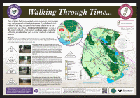
Walk No 4: Starting from Boldmere Gate
Suggested route about 1 mile (1 hour)
The road to Boldmere Gate (Stonehouse Road) runs alongside the large grassy dam of Powell’s Pool, which was built in 1730 and powered a watermill which made spades and later rolled steel. There were experiments in using water power to spin cotton here.
Walk straight ahead from the panel along the tarmac road to a junction of tarmac roads.
Marker no 4.1 is beside the road on the edge of the wood
The bank and ditch (woodbank) constructed around Holly Hurst in the 16th century to keep grazing animals out of coppiced wood. It was built on top of an earlier boundary, which had a ditch on the other side of it, and was a subdivision of the medieval deer park to create an enclosure into which deer were rounded up for hunting.
Turn right along the tarmac road into the wood.
Marker 4.2 is beside the road just inside the wood
The path to your right takes you to one of several sawpits where felled trees were cut. The group of conifers on the other side of the road are said to mark the centre of England and are surrounded by a bank which may have been built around an observation point in the medieval deer park. You may see the tower of Holy Trinity church in the distance along the road.
Continue through the wood, turn right along a tarmac road and continue downhill.
Marker 4.3 is beside the road at the top of the hollow way.
The hollow running alongside the road is a well-worn track which ran from the manor house along the dam of Wyndley Pool and across the Park to Streetly Gate.
Continue down the tarmac road and turn right along a path at the end of the hollow.
Marker 4.4 is near the bench, with a view of Wyndley Pool
Wyndley Pool ahead of you was a fish pond constructed in the 12th century. Sutton Coldfield manor house, where the Earls of Warwick lived when they hunted in Sutton Park in the Middle Ages, stood on the hill beyond the pool.
Continue along the tarmac road, turning left at a junction, back to the start of the route near Powells Pool.
Walk No 5: Starting from Blackroot Bistro
Suggested route about 1 mile (1 hour)
From the panel walk away from the Bistro, across the car park and grass to the far end of the fence along the railway.
Marker no 5.1 is beside the tarmac road just before the railway bridge
The railway was built in 1879, in cuttings and on embankments. Midland Lodge was built by the railway company. It was rented by Benjamin Stone and meetings of the Vesey Club (a scientific club) were held there.
Walk along the tarmac road to the right, which runs on an embankment, the spectator bank of a 19th century race course. A ditch constructed in the Middle Ages runs along the present park boundary beyond the road. Further on, a small hollow on the right of the road was a quarry. Just past this, cut across the grass or turn right along another tarmac road, turn right through a small car park and continue along a path. The hollows to your right just before the marker are remains of a 19th century golf course.
Marker no 5.2 is next to the path, just beyond the car park
A prominent bank to your left and right surrounded a racecourse where horse races were held in the 19th century. Spectators would have stood or sat on the bank. A low, tree-covered bank and ditch in front of you was constructed in the 12th century to create an enclosure into which deer in the park were rounded up for hunting. The bank would have had a hedge or fence on top of it.
Continue along the path across the former racecourse.
Marker no 5.3 is next to the path
A low bank with a slight ditch alongside it subdivided the medieval deer park to create an enclosure into which deer were rounded up for hunting. The dam of Blackroot Pool was constructed in the 18th century from material dug out of the quarry surrounded by the fence.
Walk No 6: Starting from Bracebridge Pool
Suggested route about 0.5 miles (0.5 hours)
Bracebridge Pool was built in the 15th century as a fishpond. In 1577 permission was given to build a watermill (to visit the pool walk along the tarmac road).
Walk along the path down the hill.
Marker no 6.1 is beside the path
The bank and ditch (woodbank) was constructed around Darnel Hurst in the 16th century to keep grazing animals out of coppiced wood. You can also follow the bank and ditch up the hill on the other side of the road.
Walk back to the tarmac road and through the car park.
Marker no 6.2 is on the grass down the slope just beyond the car park
Trenches dug for military training, probably during the First World War, are visible as slight hollows running in zig zags so that there was no direct line of fire along the trench..
Following the path along the slope, the slight hollows on each side were more practice trenches. The railway at the base of the slope was constructed in 1879.
Marker no 6.3 is beside the path near trees.
The hollows and mounds of the “Ancient Encampment” may be the remains of gravel digging or military training relatively recently, but the ditch at the base of the slope may be much older.
Follow the path to your left along the edge of the Ancient Encampment to a gap in the trees with a view down the slope to your right.
Marker no 6.4 is beside the path
The brick wall on the far side of the road at the bottom of the hill was built in 1858 around the grounds of Four Oaks Hall. This land was originally part of Sutton Park.
Continue along the path back to the car park.